© 2023 Concerned Citizens of Western Montana
Note: We first want to qualify this article by saying that all of the time immemorial water rights awarded to the U.S. / CSKT in the Flathead Compact are fraudulent and should never have been included in the settlement. If the tribe wanted to argue “Tribal Reserved Water Rights,” that debate should have taken place in a court of law, rather than in a federal reserved water rights “negotiated” settlement under Montana law. The US / CSKT water rights in each of the western Montana river locations we looked at below are nothing more than pure government overreach by the three compacting parties: The United States, Montana, and the CSKT. These claims only exist because the compacting parties agreed to create fraudulent”Tribal Reserved Water Rights” out of thin air. The charts below demonstrate the ridiculous and precarious position that Montana has placed its citizens in by agreeing to go down this road.
We’ve been getting feedback that there are water shortages in western Montana, particularly in the Kootenai River basin. With that in mind, we decided to check and see how some of the major rivers in western Montana are faring compared to the time immemorial instream flows approved in the compact.
These charts paint a very ugly picture indeed, and the compact isn’t even in full swing yet.
If you click on the photos below you will find a document for that particular river basin including the water compact abstract, and USGS readings for the streamflow related to that particular “claim.”
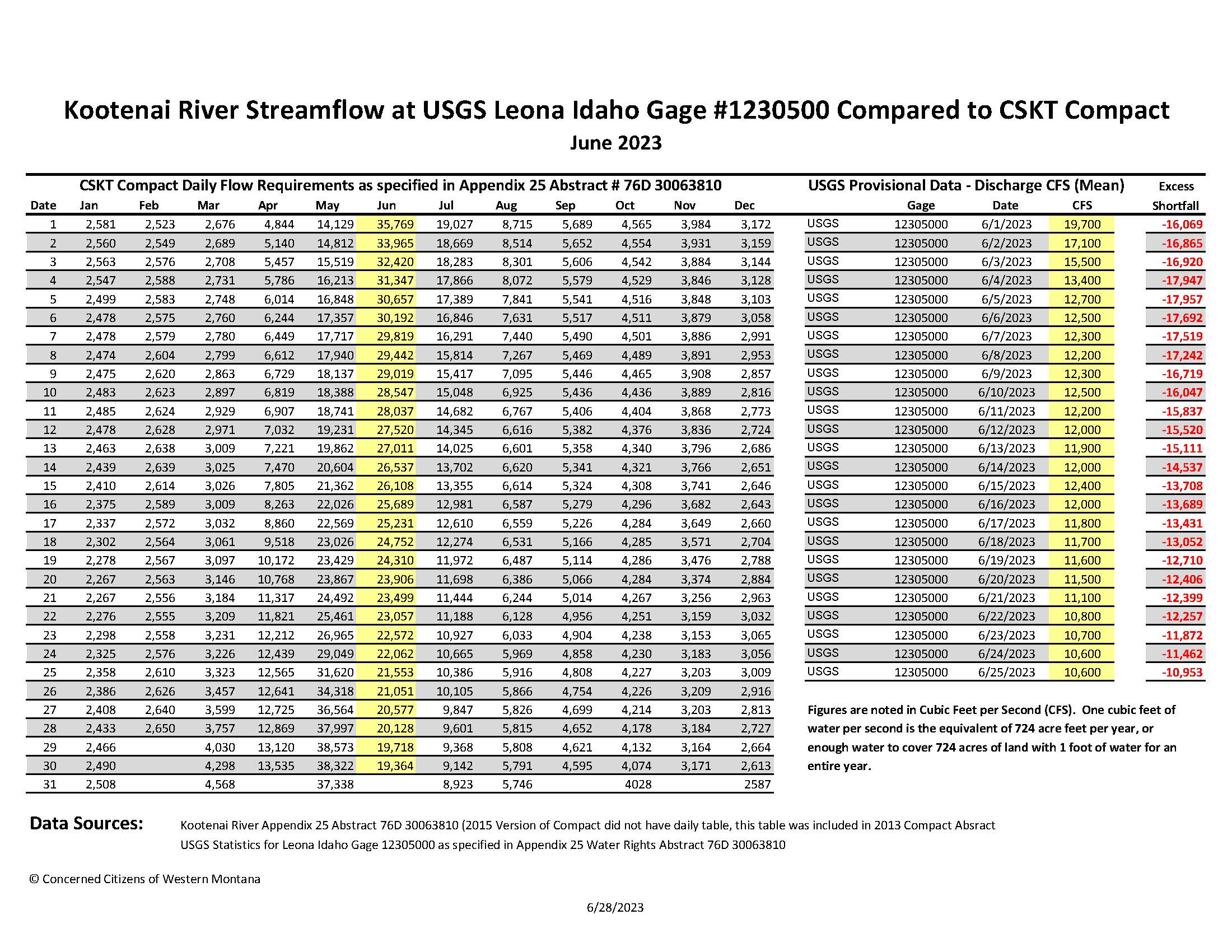
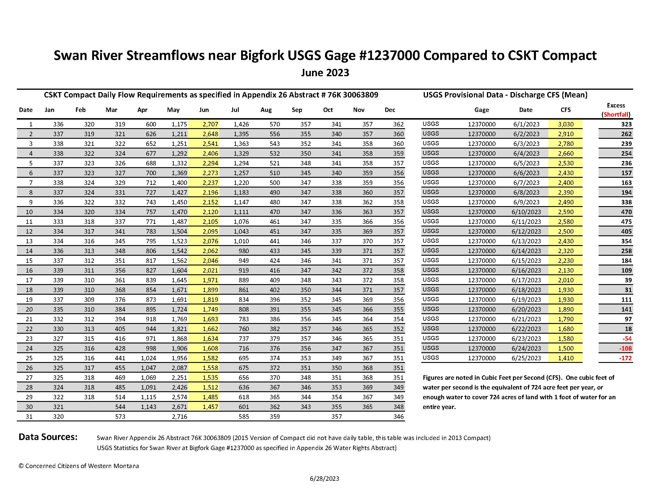
The figures on the charts below are depicted in cubic feet per second. One cubic foot per second is the equivalent of 724 acre feet of water per year or enough water to cover 724 acres of land with 1 foot of water for an entire year.
Pay close attention to the far right column on each of the charts below. Anything in RED indicates that the volume of water flowing through the river that day was below the amount of water awarded to the United States / CSKT in the compact. These shortfalls in essence have the potential to place all junior water rights (anything that has a newer priority date than time immemorial) at risk for call.
You are about to see a good bit of RED, the current implications of such shortages will be uncertain for many decades to come.
We can’t help but be curious as to whether any water calls have been made, and aren’t sure at this time where to go to find that information.
We are not sure if instream flow enforcement is triggered by the compact’s effective date (already in effect) or if they are specific to the water rights abstracts in the compact.
If no calls have been made at this point is it possible that it’s because the Flathead Compact is currently being reviewed by the water court and the compacting parties might not want to draw attention to their overreach before the water court gives the compact its blessing?
Regardless of the status of any calls on water, it is imperative for Montanans, and for legislators and other decision makers in the state of Montana to see what our state allowed to happen with our water. The information below raises serious concerns about existing and future uses of water by most of the people living in western Montana.
We also want to point out that Article III B. of the compact MCA 85-20-1901 provides for the ability to change or amend the abstracts of water rights, allowing no avenue for the public to see what those revisions may be:
Abstracts of water right appended to this Compact are a substantive element of this Compact. The language of the abstracts, including all informational remarks, shall control in the event of any inconsistency between the Compact and the abstracts of water right; provided however, that the Parties upon written mutual agreement may make technical corrections to the abstracts prior to the Parties submission to the Montana Water Court of the motion for entry of the Proposed Decree identified in Article VII.B. Such modifications are pursuant to, and shall not be deemed an amendment of, this Compact.
Additionally, Section 4(a)(3) of the Daines Legislation, buried within Congress’ massive HR133 says this about amendments to the compact and its appendices including the water rights abstracts:
Nothing in this act precludes the Secretary from approving a modification of the Compact, including an appendix or exhibit to the Compact that is consistent with this act.
Both SB262 and the Daines’ legislation authorize the Secretary of the Interior to make amendments to any exhibit or appendix to the compact and amendments or modifications to it.
In our non-legal but practical mind we think all of this means that not only can the compact be amended on the fly by the CSKT Secretary of the Interior, but “enforceability” can also be tied to future revisions, mandates and biological opinions.
So for all intents and purposes, the Flathead Compact is a living document that can be changed to fit the needs of the Tribal Council, the United States Department of the Interior, the DNRC, the Governor, our Congressional delegation, or other people who are driving the agenda behind this very bad deal.
With that in mind we also cannot know whether the prohibitions against call stated in the compact and the abstracts of water rights can be changed by the Secretary of the Interior per the terms of the compact and the Daines legislation.
As such it will be a moving target and people may not have the ability to see such revisions or to know if they are complying with the law as it pertains to their water needs.
Kootenai River:
For the first 25 days in June, the Kootenai River streamflow has been well below historic averages, and is running about 54% below the volumes of instream flow awarded to the United States / CSKT in the Flathead Water Compact. The column on the far right of the chart below shows the daily shortage of water in cubic feet per second.
The ruling document, the water right abstract for the Kootenai River says this:
THE ABILITY TO ENFORCE THIS RIGHT SHALL BE SUSPENDED SO LONG AS LIBBY DAM REMAINS IN EXISTENCE AND THE ARMY CORPS OF ENGINEERS’ (ACOE) OPERATION OF THAT DAM ARE CONDUCTED CONSISTENTLY WITH THE 2008 FEDERAL COLUMBIA RIVER POWER SYSTEM BIOLOGICAL OPINION, AND THE 2010 UPDATES BIOLOGICAL OPINION, SPECIFICALLY AS DESCRIBED IN REASONABLE AND PRUDENT ALTERNATIVE ACTION (RPA) NO. 4 (STORAGE PROJECT OPERATION). TABLE NO. 1 (LIBBY DAM) INCLUDING THE NORTHWEST POWER AND CONSERVATION COUNCIL’S 2003 MAIN STEM AMENDMENTS TO THE COLUMBIA RIVER BASIN FISH AND WILDLIFE PROGRAM, OR ANY SUBSEQUENT BIOLOGICAL OPINIONS(S) GOVERNING THE SAME RPA(S) AND OPERATIONS.
We certainly hope that the above paragraph doesn’t make people think that they have dodged a bullet in terms of water calls so they can go back to sleep. It is unconscionable that anyone would want to leave this ticking time bomb out there for future generations of Montanans to have to deal with.
While these instream flows may not yet be currently enforceable, we can’t help but wonder if these shortages may trigger other actions by the state or the U.S. / CSKT owners of the water right to ensure that the “fish are protected” because actual flows are far less than what the compact defines as “necessary” for fisheries.
We would also like to ask if the Kootenai River water rights were being actively enforced, would these shortages technically mean that no one in the Kootenai River area of western Montana could use water because the U.S. / CSKT’s time immemorial instream flows aren’t met?
We look at this chart and see that the Compact mandates that every drop of water currently flowing through the Kootenai has a time immemorial priority date, and by definition that would mean that in theory for the month of June thus far, there was no available water for any existing “junior” water rights, let alone new uses of water.
A more basic question in these instream flows is that to our knowledge, there are NO scientific studies supporting these “over the top” ‘instream flows’. In addition, the absolute uniformity of all flow requests in the compact further reinforces that there is no science underneath these flow values.
Swan River:
For most of the month of June, the Swan River Instream flows exceeded the amount of water awarded to the CSKT in the compact, however in the last three days, the Swan River didn’t produce its mandated share of U.S. / CSKT water.
Again we are not sure if any calls have been or will be initiated in the Bigfork and other upstream areas because of what appears to be possible shortages going into July.
The Swan River chart above begs the question as to how much water over and above the CSKT Compact threshold is necessary to sustain the current and future water needs of all of the people living on or around the Swan River?
Lower Clark Fork River:
During the month of June thus far, this area of western Montana is providing more than enough water to cover the U.S. / CSKT instream flow claims. It is unknown whether this comfortable daily cushion will keep those living in the area of the Lower Clark Fork River from going underwater with respect to the Flathead Water Compact.
The USGS figures included in the Lower Clark Fork River document linked below show the daily mean streamflow for the last 12 months. There are numerous dates where the flow in the Lower Clark Fork fell short of the 5,000 cubic feet per second awarded to the United States / CSKT in the compact, mostly in August, November, and December of last year.
The water rights abstract for the tribe’s claim, also included in the document above (click photo), says this about enforcement:
THE OWNER OF THIS WATER RIGHT SHALL BE ENTITLED TO MAKE A CALL IN ACCORDANCE WITH STATE LAW, TO ENFORCE THIS WATER RIGHT ONLY AGAINST JUNIOR WATER RIGHTS IN BASIN 76N (LOWER CLARK FORK DRAINAGE) AND IN BASIN 76m (MIDDLE CLARK FORK DRAINAGE) WHOSE POINT OF DIVERSION IS FROM THE MAINSTEM OF THE CLARK FORK RIVER AND NOT ITS TRIBUTARIES, THE PURPOSE OF WHOSE WATER RIGHT IS IRRIGATION AND WHOSE SOURCE OF SUPPLY IS SURFACE WATER, OR AGAINST JUNIOR WATER USERS THE PURPOSE OF WHOSE RIGHTS IS IRRIGATION, WHOSE SOURCE OF WATER SUPPLY IS GROUNDWATER CONNECTED TO THE MAINSTEM OF THE CLARK FORK RIVER AND WHOSE FLOW RATE IS GREATER THAN 100 GALLONS PER MINUTE.
Flathead River Below Polson:
This chart was a surprise to us, and we are not exactly sure what to think about it. We offer it up as one more point of reference to the water compact big picture of things.
Our first thoughts were that these numbers are contrived, and it appears that the water at Polson is already being managed to the compact levels.
But it is also possible that the numbers at Polson could be managed to Federal Energy Regulatory Commission (FERC) procedures and regulations requirements pertaining to Kerr Dam.
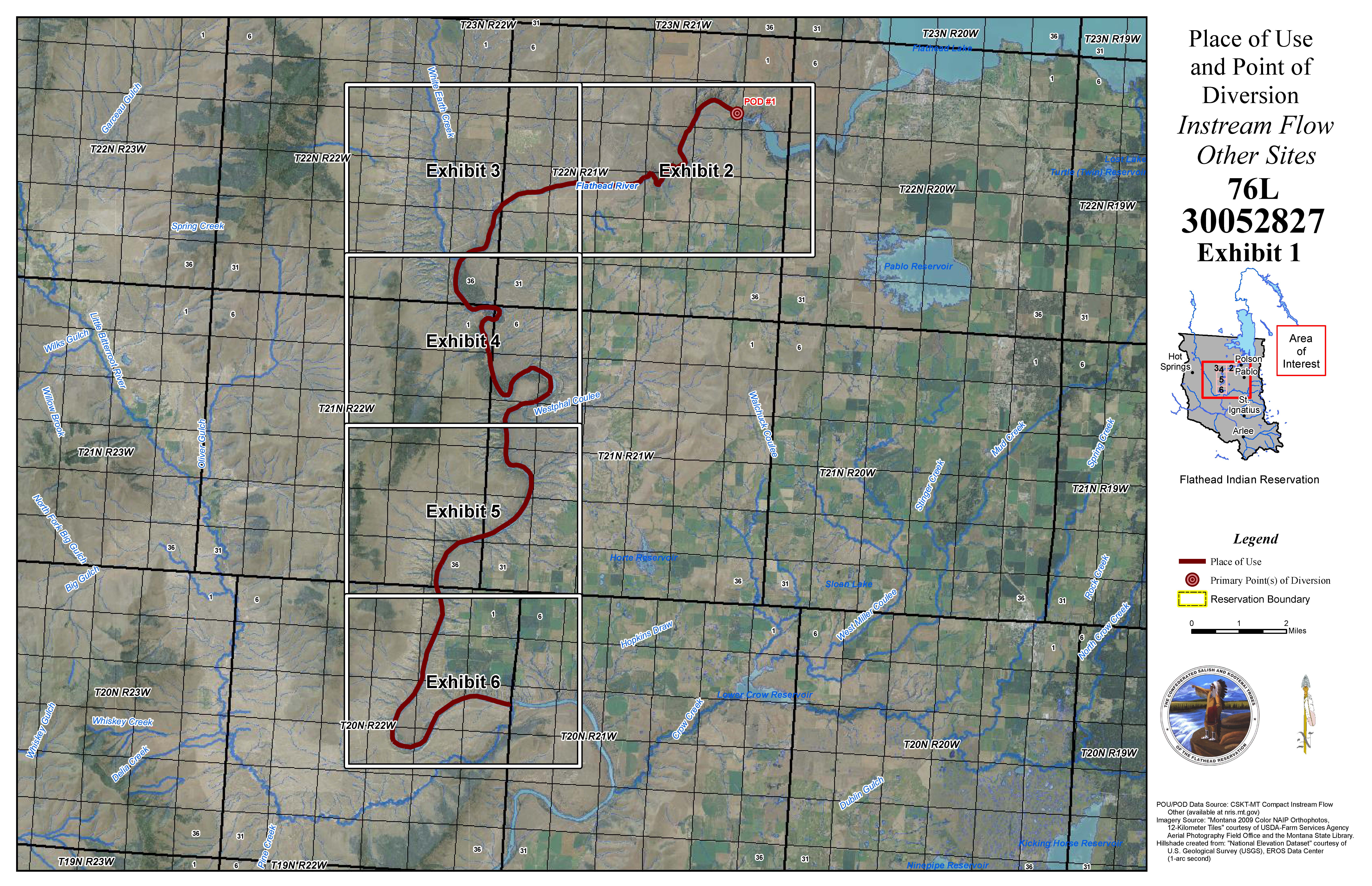
For your reference, here is a map of the area of Flathead River that pertains to the place of use and point of diversion for water right abstract number 76L 30052827. You can click on the photo below for a larger copy:
Flathead River at Perma:
The June steamflow on the Flathead River at Perma shows that the actual flow fell short of the Compact determined and mandated instream flows for the United States / CSKT.
It’s possible that these shortfalls at Perma may be because Flathead Project irrigation water uses have continued, and the compact flows are not currently being enforced by the tribe. That additional usage of water may possibly have been enough to drop water levels below the compact mandated threshold.
The flow at Perma depends on how much irrigation the Tribes “allow” to happen in the Flathead Irrigation Project, now considered by the Compact and Daines bill to be the “Flathead Fishery Project” as water is transferred from agriculture to instream flow.
Regardless it begs the question about what all of this will mean to the people living in this part of western Montana once the flows are enforced.
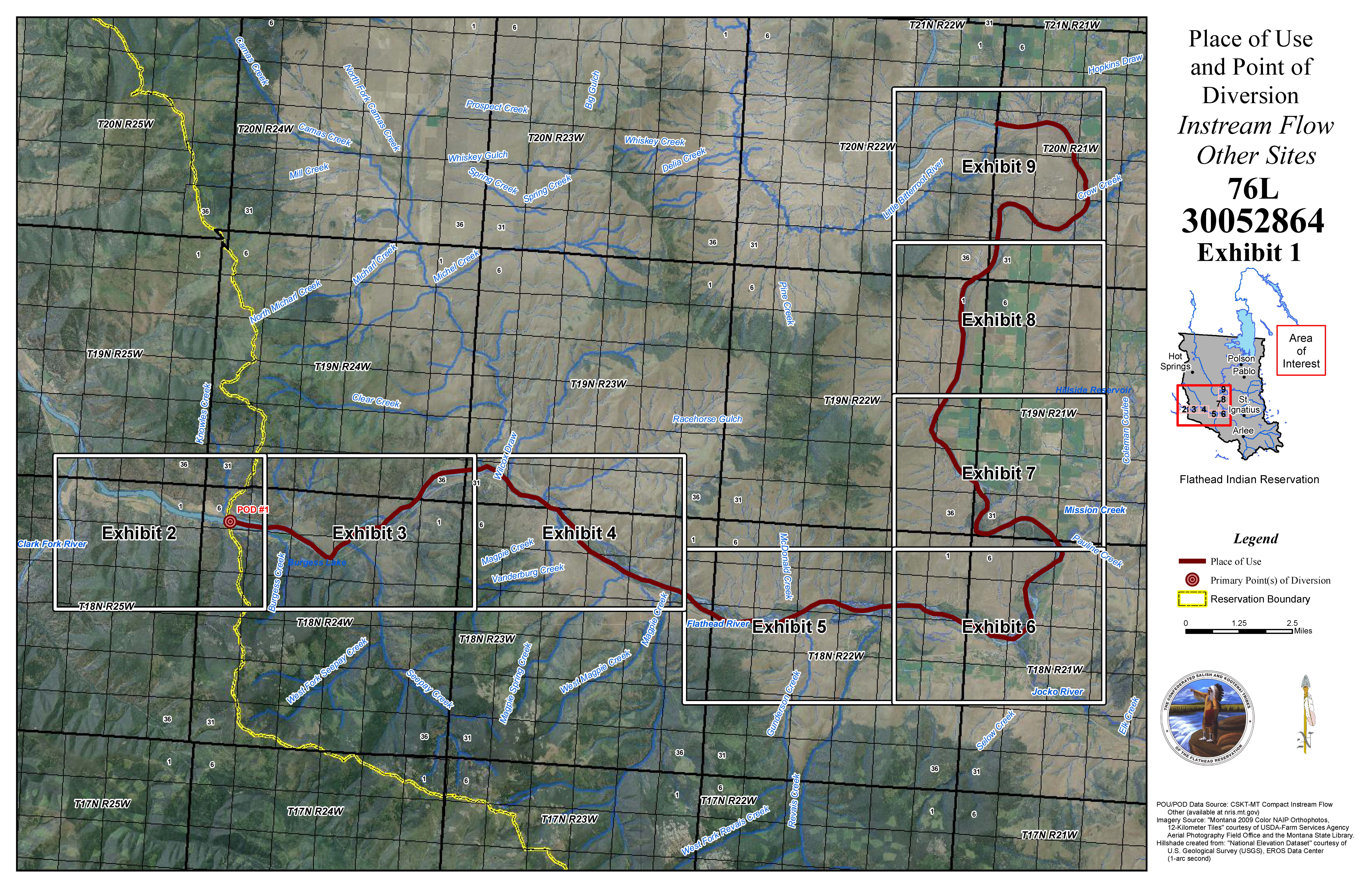
For reference, here is a map of the reach of the Flathead River pertaining to the U.S. / CSKT place of use and point of diversion for water rights abstract number 76L 30052864. You can click on the map for a larger photo:
We are hopeful that the information provided in this post gives you a clearer picture of the difficult situation the state of Montana has placed people in with respect to their water.
These charts show a devastating picture as to non-tribal current and any future uses of water throughout western Montana.
What will happen if the compact is approved by the water court and these instream flows are in full force and effect?
Will the compact ultimately set off a domino effect of water rights calls throughout western Montana in years such as this?
It seems to us that by ceding vast amounts of water in western Montana for fisheries to the US / CSKT in the compact, and giving them a time immemorial priority date, that Montana also effectively gave them control over what happens to everyone else’s uses of water as well.
With a state like this, who needs enemies?


This is an absurd disaster done by moronic feel good politicians who sign thing without reading or understanding. Giving away more water than exists!
Here’s a Daily Interlake article dated June 29, 2023 titled Flathead Lake Level Drops Prematurely:
https://dailyinterlake.com/news/2023/jun/29/flathead-lake-level-drops-prematurely/
If you are interested in looking at USGS current streamflow data for the state of Montana you can find it at this link (just scroll down the list to the Upper Columbia River Basin section for the rivers in western Montana:
https://waterdata.usgs.gov/mt/nwis/current?type=flow
Pingback: More Western Montana Water Shortage Concerns | Western Montana Water Rights
Pingback: More Pieces of the Water Puzzle | Western Montana Water Rights
Pingback: The Bigger Picture: Please Don’t Lose Sight of It | Western Montana Water Rights